-
I have the BEST FIND EVER!!! FREE Garmin Topo's & other
I did say free FREE FREE!
I am so excited I downloaded it and uploaded the map to mapsource and already installed it on my GPS while I was on Lunch! I walked outside and it picked up the Conway area great! I can post some screen shots later when I remember how, but right now I am completely happy with this find! The street names are a little hard to read, but you can hover over them and it will "pop up" on the screen. I mainly wanted this for offroad caching and now I have it! WooT!
Anyway, I'll try it out on my drive home and see how it works. It was super easy to install, I just clicked download, then I went to where I downloaded it on my pc, clicked the install, and pointed it to where I wanted it to save the image files (my garmin folder), and then waited for it to install. After that I opened mapsource and selected Arkansas Topo in the drop down box Then I selected the areas of AR I wanted to laod and Boom! It was that Easy!!!!
Some info:
* Roads - Nov. 2008 Tiger Data
* Railroads
* Census bureau water data - lakes, rivers, streams, and washes
* POIs
* Borders
* Elevation contours - 5ft, 10ft, 20ft and 40ft intervals (equivalent to or greater than 24k) built from 10m NED data
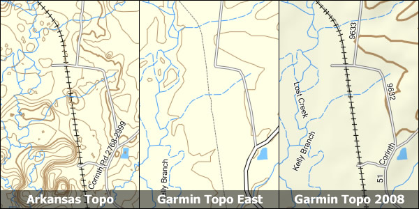
The Website picture with the Free topo on the LEFT! Pretty detailed huh?
Where is this mysterious site? Why it is here:
http://www.gpsfiledepot.com/maps/view/137/
All of the states "user created" maps
http://www.gpsfiledepot.com/maps/state/ar/
and last but not least road maps (equivalent to city nav)
http://www.gpsfiledepot.com/maps/view/19
~Yay~ :P
-
Files
I have used these for some time in Colorado, but was unaware there was a database for Arkansas. The product's best attribute out here is the increase in contour detail. Occasionally Garmin TOPO displays tighter contours but something you might interpret as a "cross-able" feature only to find in reality an abrupt impassable feature. Though "free" a lot of work goes into the project and donations are appreciated.
-
Of Course Of course. I do plan on donating, after all, they just saved me from having to buy Garmin Topo or City Nav! so deserve some of my savings. All in all was very impressed with the detail on the way home. It showed lots of waterways and roads and even the elevation lines were fairly close to what the gps was getting. I was impressed with how this gets done though, using scripts and such to scour the usgs, census data, etc to create these maps. I'm guessing these scripts can be run at anytime when new data is available to make the maps more accurate.
 Posting Permissions
- You may not post new threads
- You may not post replies
- You may not post attachments
- You may not edit your posts
-
Forum Rules


 Reply With Quote